Monday, Sep 11 2023
My primary reason for coming to Great Falls, MT was to visit the Lewis and Clark Interpretive Center and, in my planning notes, I had noted that it is closed on Mondays after labor day (which was September 4 this year). Unfortunately, it was only on Sunday evening I realized I had bungled the timing and would not be able to visit the center on my one full day here.
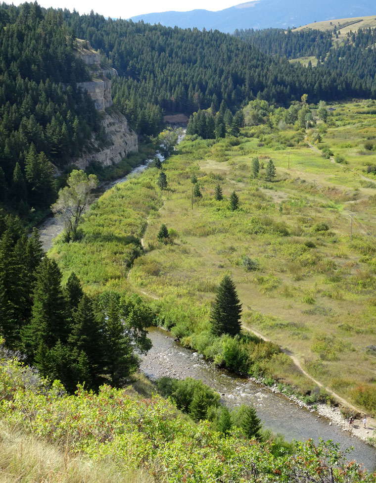
I looked for other local places to visit but “closed on Mondays” applied to all the places I found potentially interesting. The only local scenic driving is along the Missouri River and there is an extensive River Edge Trail system so I decided to make that the focus of my day.
Great Falls is named because it is an area where the Missouri river falls a total of 612 feet (187 m) over 10 miles (16 km). Most of this is due to the slope of the river bed but there were 5 waterfalls which make up 187 feet (57 m) of the descent. The largest fall was 87 feet (27 m) high and was described by Lewis as “the grandest sight I have beheld thus far in the journey” but four of the falls now have hydro-electric dams built above them, which reduces the river flow, and the fifth is submerged in a reservoir created by the dams.
After a relaxing, late breakfast I spent some time driving River Road and walking part of the River Edge Trail. Views from both were wonderful and the weather was, again, perfect.
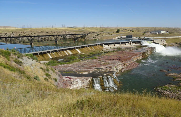
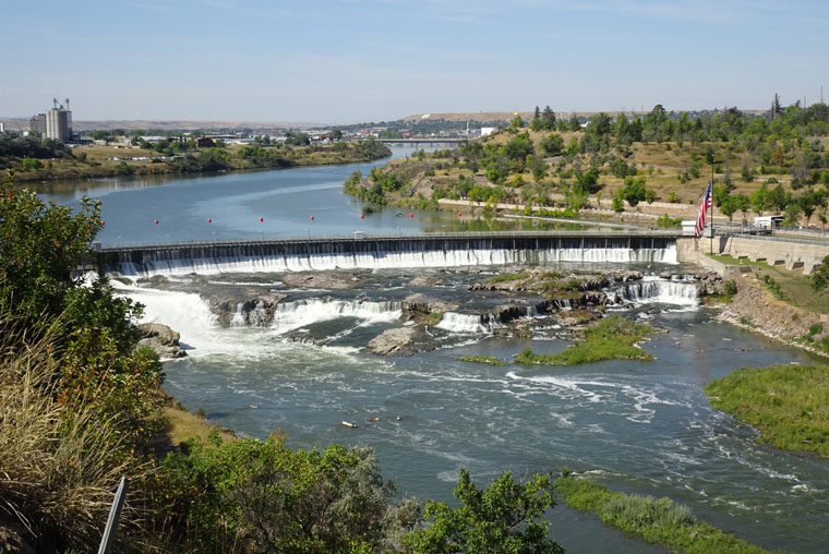
The clip below shows the burn-off at the city’s refinery which has undergone a recent conversion to produce bio-fuels and is already producing bio-diesel in quantity. The conversion also allows for the production of sustainable aviation fuel (SAF) and, when in full production, it is expected to be the largest supplier of SAF in the world. The company claims that all source materials are natural waste and all energy used in production comes from renewables. The video then pans to a close up of Black Eagle Falls and Dam as seen from the River Edge Trail.
After the scenic drive and trail walk I had a late lunch at a brew pub and pizza place before returning to the hotel to double check my future plans, do laundry etc. The lunch was an apparent mistake as I developed a stomach ache and diarrhea in the evening.
Tuesday, Sep 12 2023
The stomach issues continued until about 3 AM but, thankfully, went away as quickly as they had appeared. I had a modest breakfast then waited at the hotel for about an hour to make sure all was good before checking out. I immediately headed for the Lewis and Clark Interpretive Center where I spent the morning and then drove the 190 miles (306 km) to Bozeman, MT in the afternoon.
The National Park Service administers the Lewis and Clark National Historical Trail and has created hundreds of sites along its 4,900 miles (7,880 km) . Most of these are small with information boards, trails and directions for visitors but the Interpretive Center in Great Falls aims to tell the whole story of the amazing expedition to expand the U.S. westwards after the Louisiana Purchase from France.
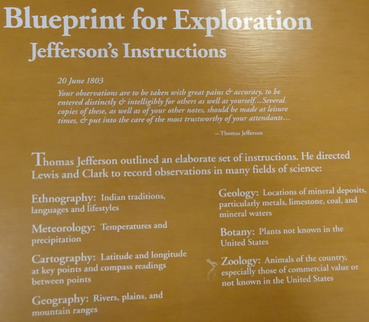
The information is presented through information boards, dioramas, videos, artifacts and interactive activities and covers the purpose, preparations, members and progress of the Corps of Discovery Expedition. The expedition was commissioned by President Thomas Jefferson after the U.S. had purchased a huge tract of land stretching from New Orleans to Montana and the Canadian border from the French. Thomas Jefferson was a very detailed and intelligent thinker and gave very precise instructions for the expedition.
The preparation and training for the 33 original members of the Corps was exquisite and their inquisitive and respectful approach to native peoples allowed this group of fully armed soldiers to engage peacefully with some two dozen indigenous nations and receive their help in the success of the expedition. Only one member of the expedition perished and that was from appendicitis. The journals and notes written by Lewis, Clark and other members of the Corps are longer than the Bible.
Great Falls is considered to represent the middle of the westward journey and its most difficult challenge. The expedition had to find a land route around the five waterfalls and haul their boats and all their equipment some 18 miles (29 km) over prairie covered with prickly pear cactus needles and across several deep ravines. This took a total of a month.
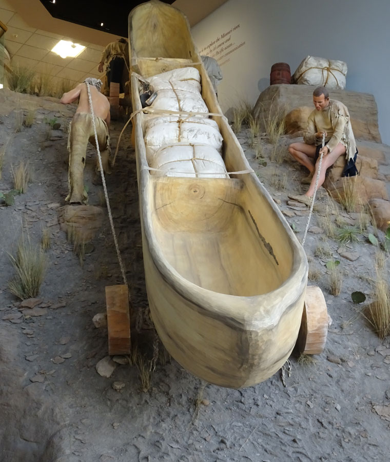
I came away with enormous respect for the courage, strength, tenacity and practical skills possessed by the members of the expedition but was equally impressed by the design, intelligence, sensitivity and research nature of the endeavor.
After leaving the Interpretive Center I took the scenic route to Belgrade (about 10 miles west of Bozeman). The scenery was pleasant but not spectacular and I stopped for a “real” breakfast at White Sulphur Springs mid afternoon.
Good to know you recovered soon. And it was fascinating to read of the Lewis and Clark expedition.
There was so much at the expedition interpretive center that I wished I had more time. It would take dozens of blog posts to even summarize the trip.
I need to work on my trip planning skills. If they could plan a two year expedition over 4,900 miles in 1805 how come I make a mistake planning a three week trip in 2023 when all the information is on the Internet?
I have a particular interest in this part of your journey. My 4th Great Grandparent was Col Nicholas Lewis, a close friend and neighbor of Jefferson, and the uncle/guardian of M Lewis. I grew up on stories of this family connection, and I’ve always been drawn to East Coast sites like Albemarle County and Harper’s Ferry that are connected to M Lewis, and also the site of his death on the Natchez Trace in TN. You’re seeing a graphic view of what the expedition required of these pioneers.
I’ve also had my revelations about how my ancestors, like Jefferson, carved out their wealth with tobacco farming on the backs of enslaved people. I’m thankful that I “woke” to this reality.
Hope you’re healthy. Be safe.
Wow, I did not know of that connection. I visited Monticello last year, with Rita and Christian, and they are pretty open about the relationship between Jefferson, his enslaved mistress and the business of creating wealth on the backs of the enslaved. With the founding of UVA and the depth of thought that Jefferson gave to the constitution and formation of the U.S. it is disappointing that slavery was ever considered acceptable. However, the choice of M Lewis to lead such a challenging expedition was inspired. I’m sure you would enjoy visiting Great Falls.
Good to know that you have recovered. Have fluids and don’t go eating stuff that is too much of anything. Your photos and videos are breathtaking. Driving on those roads must be so much fun. This Jefferson was so full of contradictions – at one level he saw the future and at another he was tied to the obnoxious past. Makes you reflect on the Yin and Yang of history.
Thanks. Trying to take care of myself. Hopefully, more scenic photos/videos to come in the next few day. People are complex.